
1. Copy and paste the following html code, for each instance where a footnote is required. Place citations within the <bracketed> space indicated therein:
<details class=“collapsible”> <summary>Click to expand</summary>
<div class=“collapsible-content”> <p> This is the hidden text. You can put paragraphs, images, links, lists, or other HTML here. </p> </div> </details>
<style> .collapsible { width: 100%; border: 1px solid #ccc; border-radius: 4px; padding: 12px 16px; box-sizing: border-box; }
.collapsible summary { cursor: pointer; font-weight: bold; }
.collapsible-content { margin-top: 12px; } </style>
1. Visualizing a Village
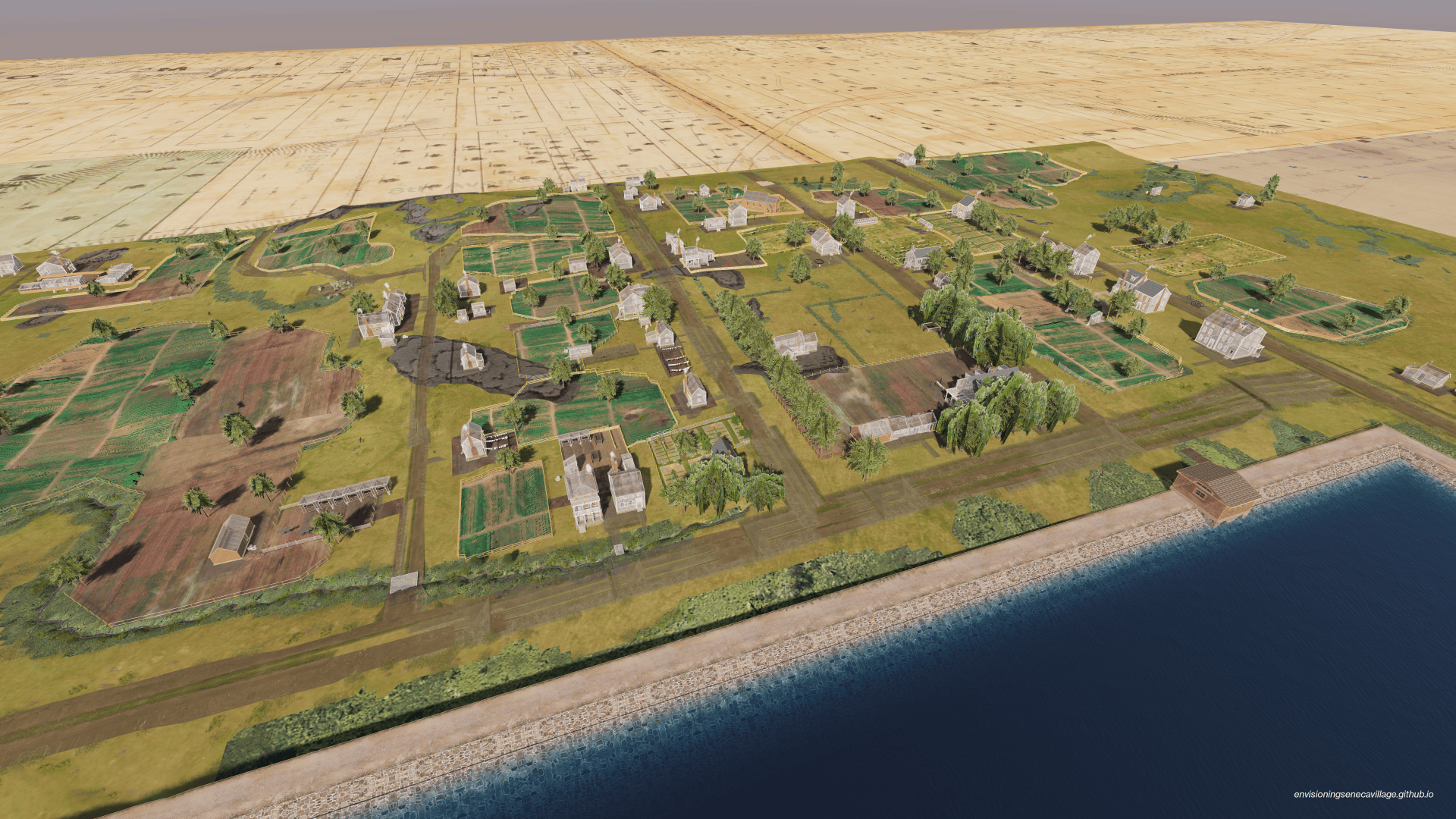
The model envisions how Seneca Village might have appeared just before its destruction in 1857. No photos or drawings survive, so our team integrated decades of historical and archaeological research with new digital mapping methods. (1) We used old maps and geographic information systems (GIS) to make an accurate map of lost roads, cemeteries, buildings, historic elevation, farmland, rock outcrops, and trees. (2) We modeled buildings with 3D software, basing their size and appearance on archival sources, archaeological finds, and informed assumptions about 19th-century architecture. (3) We added visual details and notes about villagers, drawing on social historical and archaeological research into documents (census, tax, church, etc.) and material evidence from excavation.
References
Key map sources: Sage 1838, 1856; Dripps 1851; Common Council 1853?; Serrell 1853; Viele 1855.
Key sources about architecture: Valentine 1862, 1865; McAlester and McAlester 1984; Noble 1984; Carter and Cromley 2005.
Key primary social history sources: All Angels’ Church Parish Records 1846–1858; Letters of affidavit (Mathews 1855; Pease 1855; Quinn 1855; Riddles 1855; Trustees of African Union Church 1855; Williams 1856; Webster 1856; Wallace 1857?); New York County Municipal Death Records (NYCMDR 1812–1860); New York City Property Tax Assessment Records (NYPTAR 1828–1855); New York State Census (NYSC 1855); US Federal Censuses (USBC 1830, 1840, 1850, 1860).
Key social history and historical archaeological secondary sources: Rosenzweig and Blackmar 1992; Hodges 1999; Harris 2003; Wall et al. 2008, 2019; Manevitz 2021; Miller 2022; Linn et al. in press.
About the collaborative historical archaeological project: Wall et al. 2004; Linn et al. 2023.
Archaeological site report: Wall et al. 2018.
2. Nanny Goat Hill

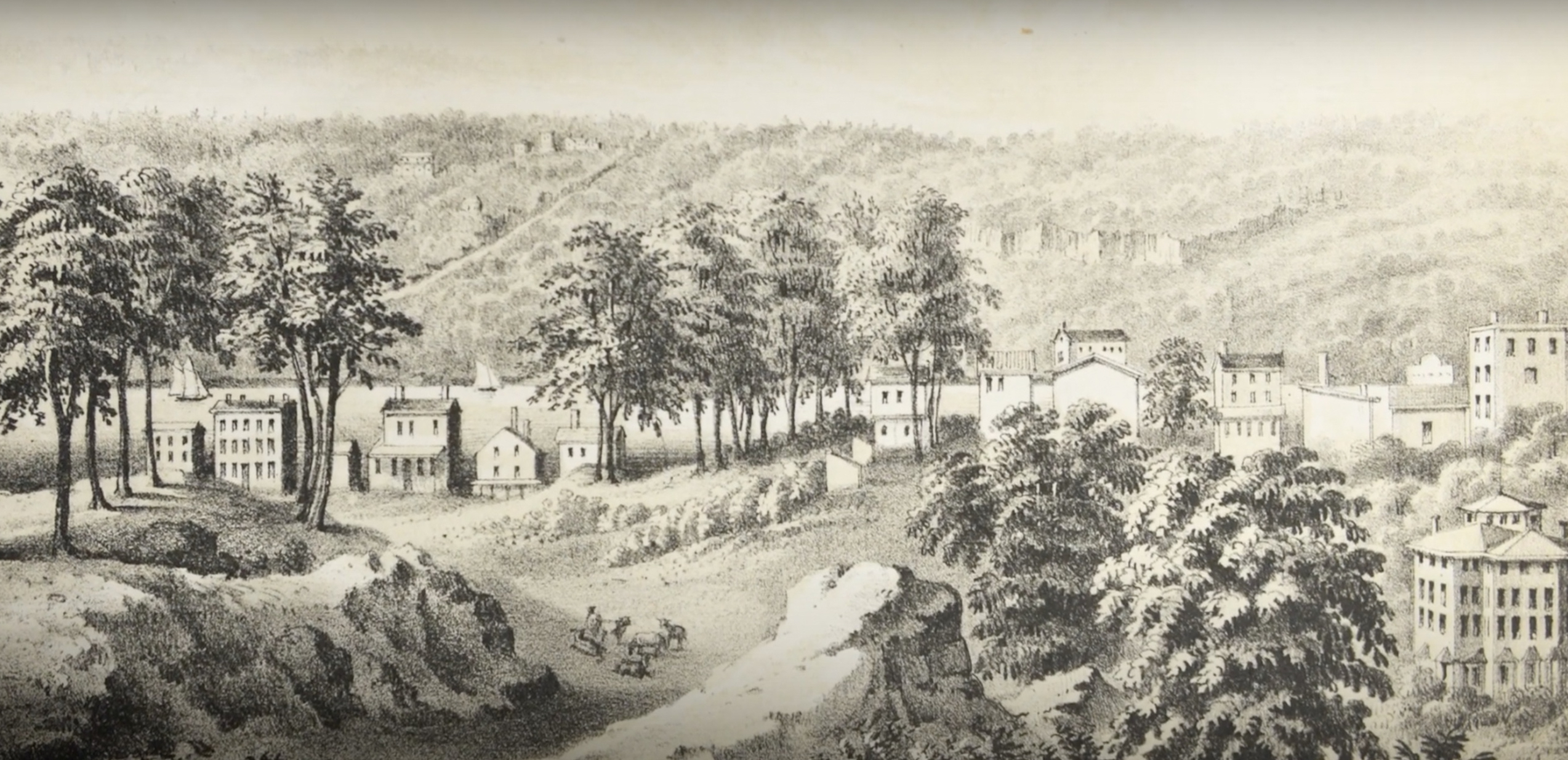
The highest point of natural elevation in Central Park is a giant outcrop of schist bedrock, 142 ft above sea level, today called Summit Rock. Seneca Villagers reportedly called it Nanny Goat Hill, likely reflecting how they used it to graze animals. From it, visitors today can still see the many bedrock outcrops that distinguish the landscape and made large-scale farming and construction difficult in the past, partially explaining the area’s slow real estate development. The hill offered views of the rolling terrain of the nearby village of Bloomingdale, the Hudson River, and the Palisades of New Jersey to the west and the imposing Croton Receiving Reservoir and Yorkville to the east. To the south, the urban core of the city grew closer, reaching approximately 14th Street when Seneca Village began in 1825 and 42nd Street when the city destroyed the village in 1857. For more than 30 years, the hill sheltered a thriving community founded by African Americans.
References
Elevation: Viele 1855.
Name of hill: Rosenzweig and Blackmar 1992, 66 citing New York Times 1924:16.
Surrounding areas: Hooker 1828; Dripps 1851, 1852.
Linked illustration “View from Summit Rock West”: Viele 1857.
Community founded by African Americans: Rosenzweig and Blackmar 1992, 65–73.