Demolishing Public Space at New York Penn Station

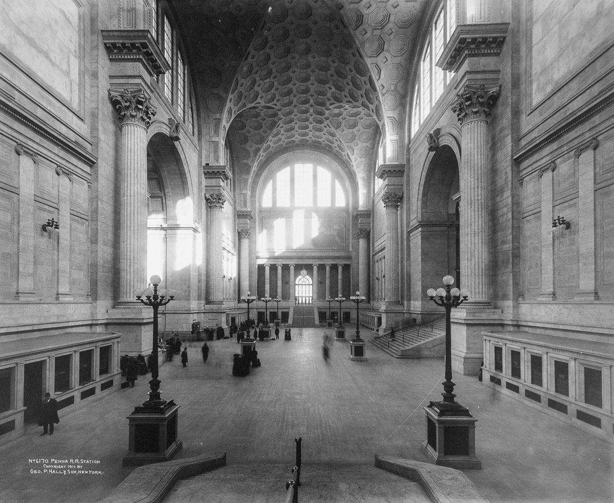
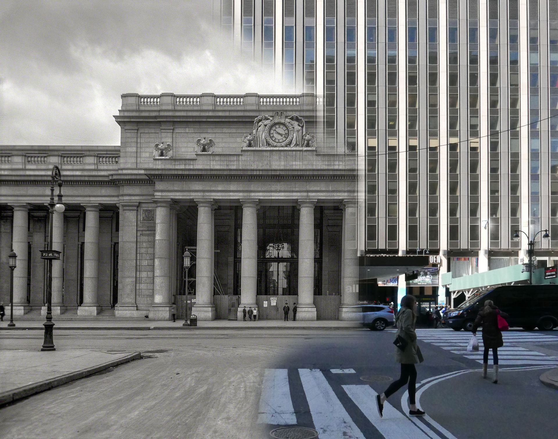
What does old Penn Station’s loss reflect about the evolution of public space in New York City? Written with Evander Price, recent PhD student in American Studies and chronocriticism at Harvard. Thanks also to Adam Brondheim for his insights about historic preservation in NYC. Download this essay as a PDF file The old waiting room, once the largest indoor public space in New York City, is now a parking lot. Demolition crews began hacking away at the limestone walls, stone eagles, and thirty-foot tall Doric columns of old New York Penn Station in October 1963. In a construction industry where… VIEW PUBLICATION

Excavating Old New York Penn Station

This historical essay and narrated film comparison of past vs. present explores the historical significance and transformation of Pennsylvania Station in New York City. Originally a grand architectural masterpiece from 1910 that embodied neoclassical design and values, the station was demolished in the 1960s, in order to build a modern structure that lacks its predecessor’s grandeur. This shift reflects both economic decisions and the ongoing struggle between community and capital to shape the future of New York City’s public spaces. VIEW PUBLICATION

24 Hours in the London Underground

Audio effect: Heartbeat from Freesound Through analyzing 25,440 data points collected from 265 stations, this animation visualizes commuting patterns in the London Underground over two weeks in 2010. Each colored dot is one underground station. The dots pulsate larger and smaller in mathematical proportion to the number of riders passing through. Big dots for busy stations. Small dots for less busy stations. Dot color represents the lines serving each station. White dots are for stations where three or more lines intersect. Each dot pulsates twice in a day: Once during the morning commute; and again during the evening commute. By… VIEW PUBLICATION

Railroad commuting patterns in New Jersey

View my data visualizations of New Jersey’s suburban growth here. Created with data from NJ Transit on weekday and weekend rail ridership. Or download my data from Tableau Public. NJ Transit carries over 90,000 commuters per day to and from New York Penn Station, the busiest rail station in the Western Hemisphere. The construction of this rail network in the nineteenth and early twentieth centuries was focused around New York City. Like spokes on a wheel, these rail lines radiate from the urban center. Hover over stations to view statistics. Dot color corresponds to train line. White dots are for… VIEW PUBLICATION

Northeast Corridor railroad time-lapse

Audio effects from Freesound; music is Metamorphosis by Philip Glass The Northeast Corridor is the busiest passenger railroad in North America. This drone flight follows a high-speed Acela train making this 456 mile journey from Washington D.C. to Boston via Baltimore, Wilmington, Philadelphia, Trenton, Newark, New York City, Stamford, New Haven, and Providence. This animation was created from Google Earth satellite imagery. I traced the Northeast Corridor route onto the ground, and I then programmed the computer to follow this route. I then added the inset map, sound effects, and clock in post-production. The above animation is condensed. View the full… VIEW PUBLICATION

New York City Subway Ridership

Created with data from the MTA.Published by Gothamist on 22 January 2019.Related: my data visualization of London Underground commuting patterns. The visual language of data addresses a deeper need to humanize and soften the concrete jungle. Sounds of breathing, heartbeat, and subway from Freesound In this animation based on subway ridership statistics by station: ● Dots are color-coded according to the subway lines they serve. ● White dots are for junctions between two or more lines of different color. ● Dot size corresponds to the number of riders entering each station within a 24 hour period. ● Larger dots are for… VIEW PUBLICATION