• This website includes dozens of videos, hundreds of essays, and thousands of drawings created over the past twenty years. Search to learn more about the history of buildings, places, prisons, Newark, New York City, and my PhD research on spatial inequality.

  • Or scroll down for the latest publications.

Setting Up Sex Offenders for Failure

How the intersection of law and city planning exposes sex offenders to longer prison sentences

Published to the AGORA: Issue 18, 2023-24
The Urban Planning and Design Journal at the University of Michigan

.

Abstract:

Our nation’s laws for sex offenders, although designed to protect the public, often have the opposite effect: increasing the chance sex offenders will be re-arrested and re-convicted for new crimes. The core of the problem is not that public safety rules, like Megan’s Law, are too weak. The problem is that these laws are written too strongly and too powerfully that they have the reverse effect: increasing the chances that sex offenders will commit new crimes. There are many problems with sex offender laws: too weak in areas they should be stronger; too strong in areas where they should be more flexible. But today I will examine just one aspect of the sex offender registry (the home address requirement) and how it affects one place (New York City). This analysis of New York City points to concrete and better ways to protect public safety than the current system: ways that reforming Megan’s Law will increase public safety.

.

Article:

Download article as PDF / open in new window >

.

Acknowledgements:

Thank you to dissertation advisers Dan O’Flaherty for his research on homelessness and Mary Gallagher for her advice on case law. This essay was originally written for Heather Ann Thompson’s fall 2023 PhD seminar on The American Carceral State. Most of all, thank you to editor Jessie Williams for her patient and insightful line edits.

Mapping Manhattan Chinatown’s Public Realm

.
Created with architect and urbanist Stephen Fan for City as Living Lab
Funded by the University of Michigan’s Rackham Program in Public Scholarship

Inspired by reading the book Manhattan’s Public Spaces:
Production, Revitalization, Commodification
by Ana Morcillo Pallarés

.


View full size image.

Chinatown’s Public Realm

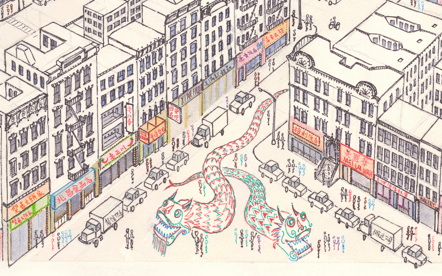
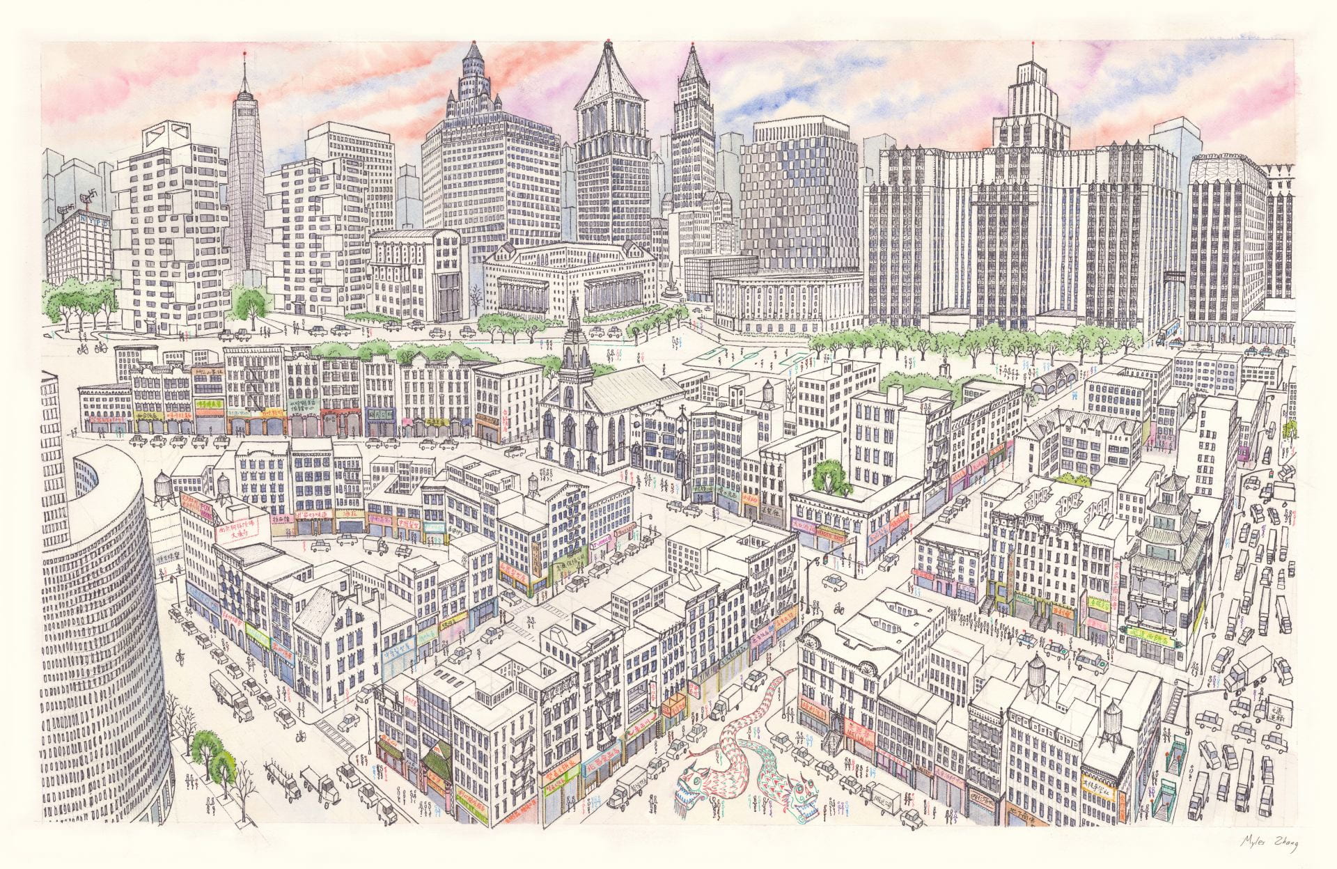
Along Mott Street, boxes of fruits and vegetables from the US, Latin America, and China flow from the private open storefronts and onto the public sidewalks and curbs. Forklifts navigate around crates and delivery trucks as vendors, residents, tourists, and shoppers–from regional Asian restaurant owners to West-African immigrants–animate the narrow walkways. After business hours, private produce stands become public places to sit, chat, people-watch, or nap as a sidewalk masseuse sets up two chairs on the public sidewalk to provide his private services.
Away from the commercial corridors, teenagers sit in circles sipping on bubble tea on the Pace High School track while senior citizens slap playing cards on a makeshift table along the track perimeter. Inside the Chinese Consolidated Benevolent Association, teachers begin their Chinese language class while protesters in Columbus Park call for ending violence against Asian Americans.
In creating this map, we hope to stimulate conversations about how public space can be better used, designed, managed, and reimagined: to inspire action in shaping a more resilient and inclusive public realm.

.

.

Read the map in English and Chinese PDF. 阅读简体中文版

2,500+ copies printed and distributed

.

.

.

Credits and Collaborators:

In alphabetical order

Stephen Fan – co-author

Lulu Barry – map docent
Kari Conte – CALL staff
Liza Cucco – program manager
Olivia Georgia – executive director of CALL
Shane Keaney – graphic designer
Rebecca Lucher – programs and operations
Mary Miss – founder and artistic director of CALL
Calla Flood Tardino – CALL staff
Chloe Zhang – map docent

.


.

.

Process

This map illustrates the public/private uses/spaces of Manhattan Chinatown’s pedestrian life. The map is divided into two sections: the upper depicts public spaces, and the lower section private spaces. From left to right are a spectrum of private to public uses.
In consultation with Chinatown residents and based on a series of walking tours and community forums, we developed the themes and activities shown on this map. We were inspired from reading Jane Jacobs and Michael Sorkin’s descriptions of street life and the delicate balance of public vs. private uses that play out on the city sidewalks. We hope this map will be a classroom and community resource to equip the public with a language and questions to interrogate their own built environments.
Below are scenes from a community event we held in summer 2021. Chinatown residents were invited to annotate an early draft of our map with their experiences and memories of the community.
In addition, over spring and summer 2024, City as Living Lab commissioned two students as map docents – Lulu Barry and Chloe Zhang – to sit in front of the map each Friday and Sunday afternoon. They engaged in conversation at their table with passing Chinatown residents and tourists, sharing insights from the map and eliciting community responses to this project. Thanks to their work, this project now has a larger audience and copies of the map are distributed across dozens of Chinatown community partners.

.

Walking Tours and Community Meetings

From summer 2024

.


Chinese music: Feng Yang (The Flower Drum)

.


Does the American city need a new “public entrepreneur” like Robert Moses?

Performing winter 2022 at The Shed in Hudson Yards is Straight Line Crazy, a two-act play about Robert Moses. He was New York City’s leading planner from the 1930s through 1960s, responsible for 35 highways, 12 bridges, 658 playgrounds and over 2 million acres of parks. Since the publication of Robert Moses’s 1974 biography The Power Broker by Robert Caro, Moses has been variously remembered for the thousands of projects he completed, admired for those public parks that brought communities together, hated for his proposal to carve an expressway through Lower Manhattan, and despised for those infrastructure projects that divided non-White communities.
Act one builds up Robert Moses as the Oxford-Columbia educated planner but with slight populist tendencies in his construction of Jones Beach and hundreds of playgrounds. This script for public consumption is of course incomplete without the mandatory repetition – originating from The Power Broker – that bridges over the access roads to public beaches were too short for buses of Black people to pass under.
Act two takes down Moses by trotting through the usual history with mentions of the 1960s Cross Bronx Expressway. Out of 250,000 people displaced citywide for “slum clearance” and “urban renewal” projects, that highway alone displaced some 40,000 people – mostly tenements of working-class immigrants. In the final scene, a young Black architect employed in Moses’s office repeats James Baldwin’s 1963 claim that “urban renewal means … Negro removal” and confronts Moses saying that her family and everyone she knows was displaced for the Cross Bronx.
That a city planner should be the subject of an off-Broadway play speaks to the enduring power of Robert Moses in the public imagination. Robert Moses succeeded in a profession now weighed down by paperwork and bureaucracy. In his complete vision of a city and ability to execute projects in face of the odds, Robert Moses represents the total power many planners and architects today secretly – or not so secretly – wished they had. Like him or hate him, we cannot seem to forget him.

Read More

.

Architecture of Endurance in Manhattan Chinatown

As featured by City as Living Laboratory
And the Municipal Art Society of NY

.

Eldridge Street Synagogue and Manhattan Bridge

.

Welcome to Chinatown. With a population of ~150,000, this neighborhood is the largest ethnic Chinese community in the Western Hemisphere. Join us on a mile-long walk through space and time.
A few questions to keep in mind during our walk:
+ How has Chinatown changed over two centuries of urban growth? What has not changed?
+ What other cultures and ethnicities lived here before or simultaneously with the Chinese?
+ How are the challenges the Chinese faced imprinted on the built environment of Chinatown?
+ How does Chinatown street life blur the boundary between public and private space?

.

Interactive Tour Map

.

Read More

.

Thank you to Liza Cucco, Olivia Georgia, and Stephen Fan for co-creating this virtual tour. City as Living Laboratory has been exploring this neighborhood through walks for many years. A recent initiative explored issues of climate, equity, and health in Chinatown’s unique food system.

.

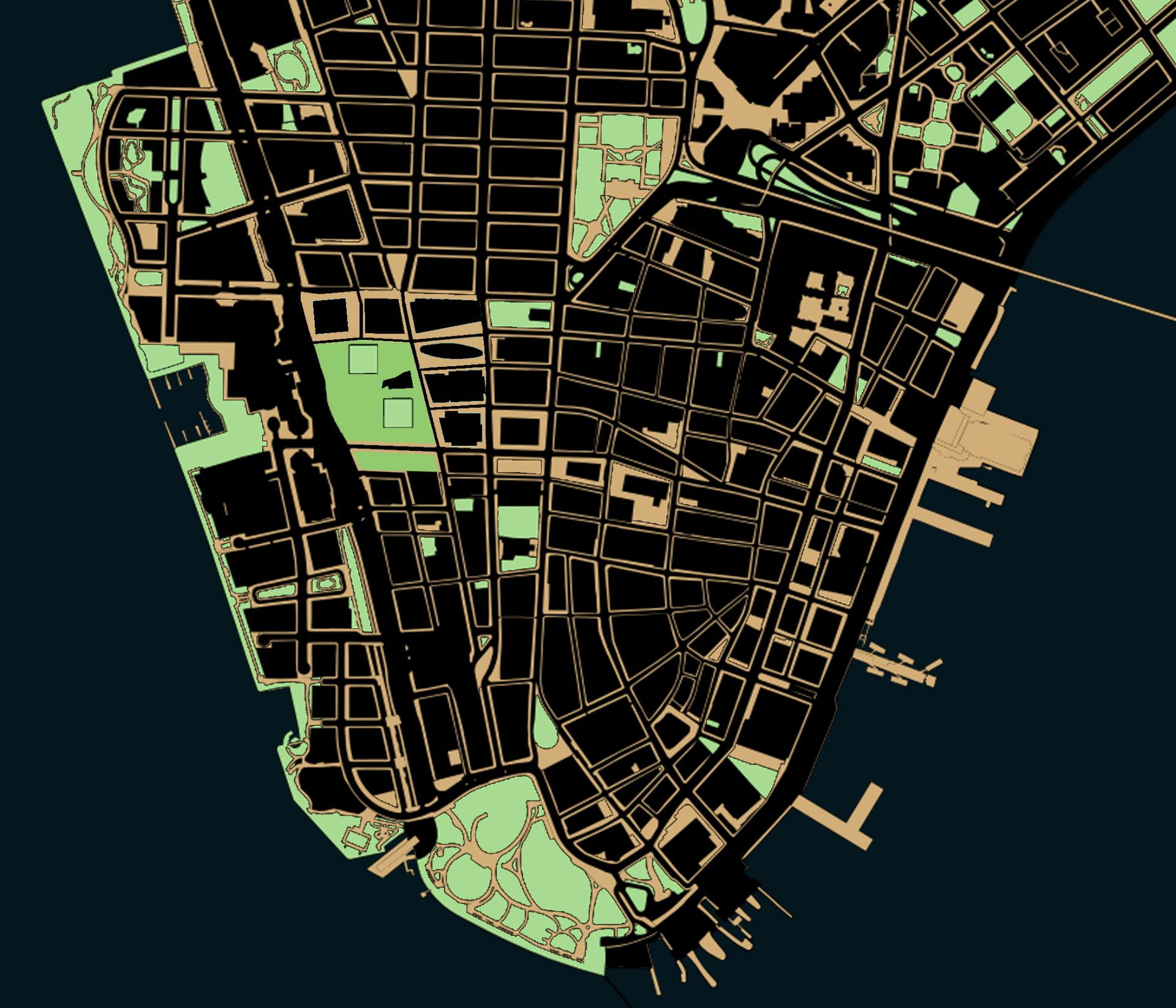
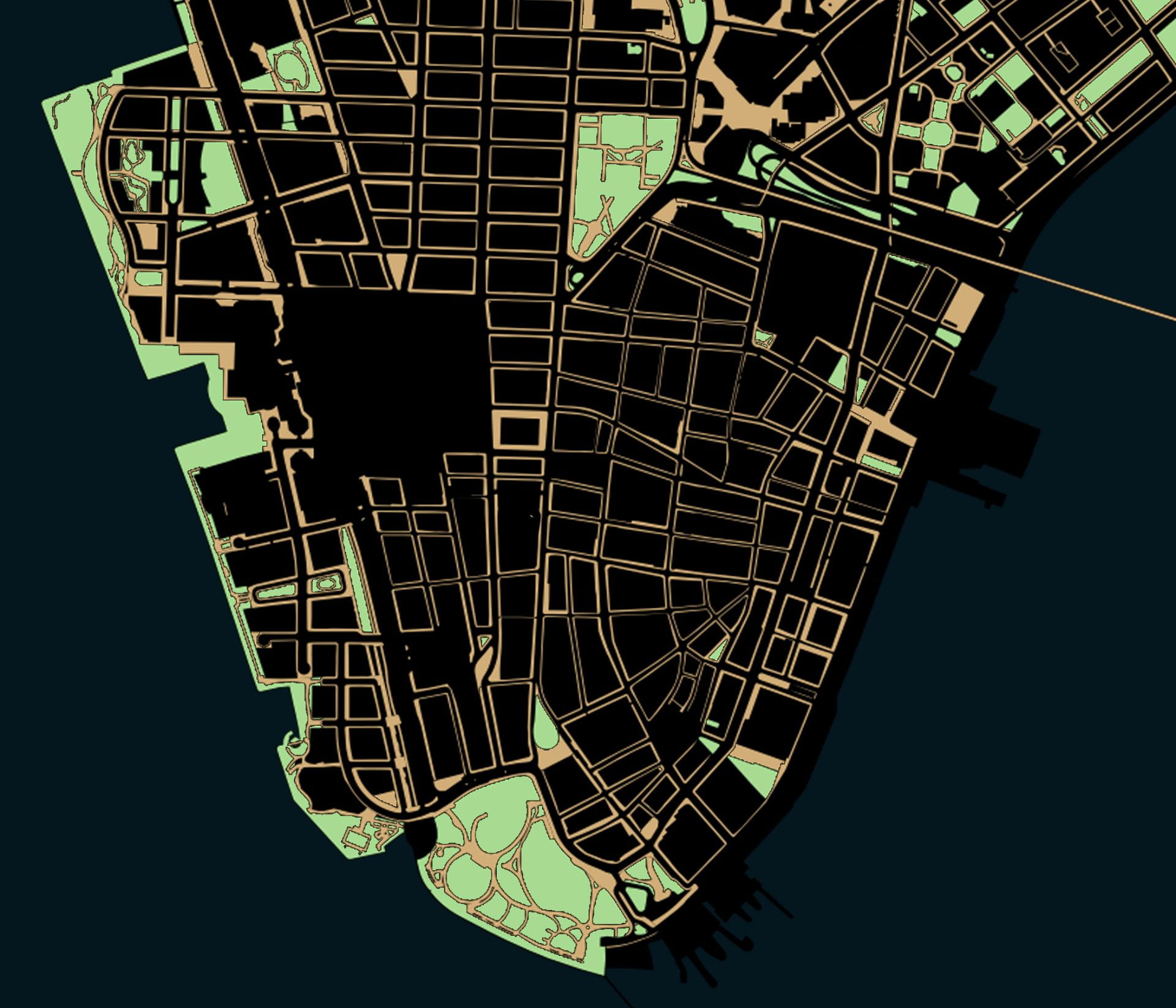
The Privatization of Public Space in Lower Manhattan

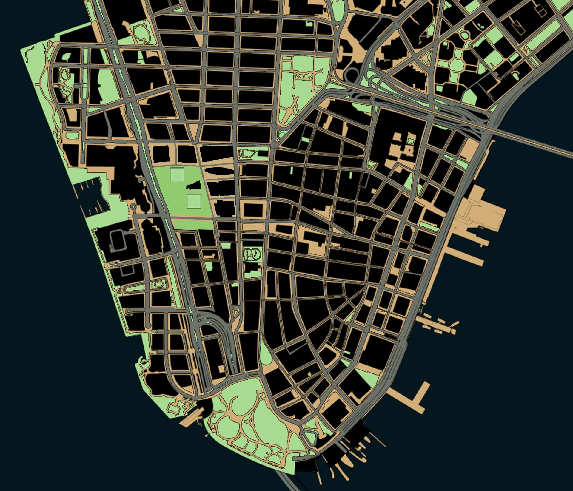
Map created by author in QGIS with planimetric data from NYC Open Data

.

More than a specific threat to New York City, the decades-long erosion of public space is an existential threat to democracy.

About 60% of Lower Manhattan’s surface area is listed as being public in some way, but only about 25% is totally unrestricted to the public in practice.*1

.

New York City – and the world’s wealthiest corporations headquartered in Lower Manhattan – had much to do with inventing and spreading new technologies that influenced the urban form. Construction companies like US Steel at 165 Broadway supplied materials for the highways that sliced through cities. Car companies like Chrysler in Midtown encouraged America’s affair with gasoline. Groups like Chase Bank at 28 Liberty Street supplied home loans for whites-only suburbs. Stores like Woolworth at 233 Broadway helped replace small businesses on main street with one-stop department stories and suburban shopping malls. Above them all, the New York Stock Exchange at 11 Wall Street supervised the twentieth-century migration of wealth and capital from American industrial cities to foreign countries with cheaper labor. These changes might have started with the “titans of industry” perched in Lower Manhattan’s skyscrapers, but highways, cars, home mortgages, shopping malls, and de-industrialization all had consequences for the rest of us. This makes Manhattan the ground zero – and in more ways than just September 11 – to understand the forces shaping the loss of public space.
Over the past century, three forces in Lower Manhattan have been chipping away at the quantity and quality of public space: the car, the corporation, and the police state. Each of these three forces effected Lower Manhattan in particular and the nation at large. Each of these three forces, prompted by changes in technology, reshaped the urban form: 1) the invention of the affordable and mass-produced car that substituted for public transit; 2) the abandonment of cities for suburbs that was enabled by the car and encouraged by corporations; and 3) the invention of surveillance technologies to collect, store, and analyze data collected from public spaces. Each of these three technologies were, in turn, weaponized against the urban form to chip away at spaces that once belonged to society at large but which now belong to a select few. Each force will be analyzed in turn – the car, the corporation, and the police state – to reflect on the impact of each on Lower Manhattan’s urban form.

.

Public spaces in theory:
~60% of Lower Manhattan’s surface area

Read More

.

  1. * Percentages are rough estimates from author, based on area south of Chambers Street with planimetric data from NYC Open Data. An exact estimate is impossible to arrive at because there is no single definition of public space.

Street Grid Development vs. Population Density

Adapted from Shlomo Angel and Patrick Lamson-Hall’s NYU Stern Urbanization Project,
here and here.

.

The animation at left shows street grid development from 1801 to 2011, mapping Manhattan’s gradual expansion north. The animation at right shows the population density over time of each census tract in Manhattan. Notice how Manhattan’s population density rises and peaks around 1900 before falling to present levels. Despite Manhattan’s appearance of being denser and more built up with skyscrapers than ever before, the island actually has a lower population density than a century ago.

.

.

Before the introduction of subways in the early twentieth century, the difficulties of commuting distances over land and water drove a denser form of urbanism than today. By 1900, the island of Manhattan had over 2.3 million residents in comparison to only 1.6 million in 2020. These people were crowded into dense blocks with upward of half a million people per square mile. The subways had not yet opened, suburban sprawl had not yet arrived, there were no rail connections under the Hudson River, and Manhattan had few or no road connections with the other boroughs and the mainland. This produced an island of remarkable density with the Lower East Side the densest place on earth, while only a few miles north, Harlem remained almost rural.
In 1903, the Williamsburg Bridge over the East River linked the Lower East Side with undeveloped Brooklyn. The trolley lines, subways, and roadway that stretched over the Williamsburg accelerated the development of Brooklyn, first in the higher density parts of Brooklyn closest to Manhattan and later to the distant parts of Brooklyn and Queens with suburban population densities. Suburban growth started earlier than the 1950s image of Levittown, and with the movement of people outwards from Manhattan, the centers of immigrant cultural life shifted, too. In every following year, the Lower East Side lost people, arriving at a density in 2020 only a sixth of what it was in 1900.
Over the following decades, improvements in public transportation and the introduction of the car “smoothed” out the population density. At the same time, Manhattan’s street network expanded to cover the whole of the island from end to end. As the subways made commuting easier, people no longer need to live within walking distance of where they worked. As a result, many industries remained in Manhattan while their workers moved to other boroughs, and later still to the more distant suburbs. As a result, the population densities of Manhattan today are more consistent from one end of the island to the other. Unlike in 1900, Harlem today is about as dense of the Lower East Side because transportation has made one part of the island almost as accessible to work as any other part of the island.
This animation illustrates Manhattan specifically, but Manhattan’s growth and population densities were influenced by larger population and technology changes in the New York region.

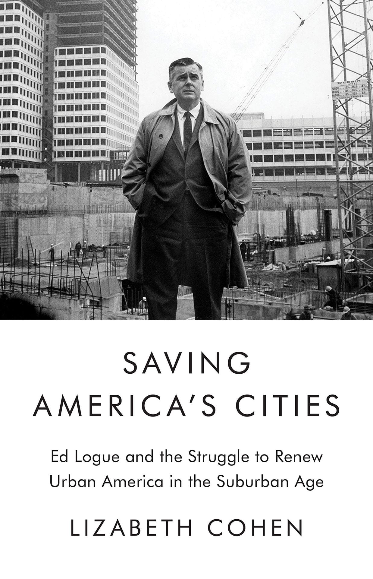
Book Review of “Saving America’s Cities”

Lizabeth Cohen. Saving America’s Cities: Ed Logue and the Struggle to Renew Urban America in the Suburban Age.
New York: Farrar, Straus and Giroux, 2019. 547 pp.

.

The memory of mid-century urban renewal will always evoke images of the bleak brick towers and windswept plazas of crime-ridden public housing. Urban renewal projects airdropped into the city fabric caused demolition and dislocation. This colossal failure has been epitomized by Robert Moses’ automobile-oriented vision of New York City. The Power Broker by Robert Caro described Moses stubbornly going alone to remove 1,500 families and pave the Cross Bronx Expressway through their vibrant neighborhood.[1] By contrast, in The Death and Life of Great American Cities, Jane Jacobs vividly described a sentimental city life with lively streets of safe neighborhoods. Pedestrians stroll along short city blocks while residents watch from brownstone stoops in her quaint Greenwich Village alleys.[2] The two polarized visions of activist Jacobs vs. authoritarian Moses have set the terms of the debate on city design and, by extension, about the government’s role in structuring urban life. Lizabeth Cohen, a Harvard historian of twentieth-century America, critiques the current dichotomy: “The lack of subtlety that I have lamented in current historical understanding of postwar American urbanism stems partly from its frequent framing as a monumental battle between the clashing visions of the villainous Robert Moses and the saintly Jane Jacobs.”[3] Between these two schools of thought, Cohen introduced the largely forgotten “Master Builder” Ed Logue to dispel misconceptions about urban renewal.
Logue serves a curious alternative to the polarity between Jacobs and Moses. Despite her biographical focus, Cohen does not lionize Logue’s dedication, but recounts his lifetime of successes, false starts, and imperfections. Logue came from a Philadelphia working-class family with an Irish Catholic background. Serving as a bombardier during WWII, he first experienced a top-down city vision from the air above Berlin and Dresden. Trained at Yale with a full scholarship, Logue was committed to the New Deal idealism of government serving the public good. His life, however, demonstrated how even the best of planners could not get the ill-conceived legal framework behind urban renewal to work most of the time. One reviewer of Cohen’s book asks in Architect Magazine: “How could such a clear-eyed, honest, and progressive guy, talented at getting lots of money from the federal government, oversee so many disastrous projects?”[4]
Through New Haven, Boston, and New York City, Cohen traces Logue’s city planning career of working against far larger anti-urban political and social forces. During his time in New Haven (1954-60), Logue planned to rescue the falling city by bringing suburban shoppers downtown. He built the Oak Street Connector for shoppers’ automobiles. This highway stub severed the urban fabric with an asphalt band of parking lots and uprooted a largely low-income Black community. However, Logue’s Chapel Square Mall in downtown New Haven, with indoor shopping and garage parking, never brought in enough enthusiastic suburbanites to survive against competing forces of anti-urban decentralization. What Logue called a “pluralist democracy” in New Haven planning actually relied more on experts’ work than on input from affected citizens.
Touting his approach of “planning with people,” Logue worked in Boston (1961-67) to break the city’s thirty-year economic stagnation. Unlike in New Haven, Logue created a “negotiated cityscape” of old and new in Boston and preserved some of the oldest architecture, such as Quincy Market. However, his ambitious Brutalist inverted ziggurat of the Government Center, next to a desolate brick-paved plaza, evoked an oppressive aura. His successful housing projects, particularly in the African-American Roxbury neighborhood, defied James Baldwin’s characterization that “Urban Renewal means negro removal.”[5]
Logue’s next career move (1968-75) landed him in New York City to lead the Urban Development Corporation (UDC) for 33,000 residential units, including thousands of affordable housing. After the “long, hot summer of 1967” with riots in 159 cities, President Nixon formulated his “suburban strategy,”[6] by appealing to suburban Whites’ fears of the inner city and Black insurrection. In a hostile climate, Logue encountered his political match from suburban residents. The wealthy Westchester towns vehemently opposed Logue’s attempt to place middle income and affordable housing in their backyard. The downward spiral of urban America became unstoppable. Neither urban renewal, nor affordable housing, nor highway construction could restrain the core middle urban tax base from driving away to the alluring American dream of “little boxes on the hillside,”[7] with “a chicken in every pot and a car in every garage.”[8]
Ousted from UDC, Logue settled for the final stage of his career (1978-85) at the South Bronx Development Organization. To revive the South Bronx with affordable housing, Logue no longer turned to demolition, as the urban fabric had already been devastated by arson, blight, and White flight. Logue recognized that the government had ceased investing in shopping malls, city halls, or intensely designed architecture. Instead, as if admitting the defeat of high-density urban development, Logue worked with residents to rebuild formerly urban Charlotte Street along suburban models of prefab homes with white picket fences. In a thriving nation of suburbs, the suburb had now come to the city.
Logue’s career capstone in the South Bronx was not polished architecture that he preferred, but the development that people desired. Community participations brought all stakeholders to the table, as Logue increasingly practiced. Over time, he realized that the top-down approach taken by urban redevelopment experts had serious limitations. People in the affected neighborhoods deserved to realize their vision of urban communities diversified with respect to income, race, and age. Their voices were the best insurance for equitable services for schools, transportation, retail stores, and affordable housing.
As Cohen asserts, Logue and urban renewal defy fast judgments. Across each decade, and in each of those three cities, Logue’s urban renewal had shifting goalposts, developed at various scales, and involved different levels of community participation. To attribute the flaws of urban renewal to arrogant individuals or to austere designs for “towers in the park” is to ignore the larger picture. As Logue’s battle for affordable housing in suburban Westchester revealed, the problem rests less with urban renewal itself and more with the nation’s social, economic, and political agenda against cities.
Throughout his career, Logue’s honorable goals proved impossible. With the Cold War fever in the ‘50s, the erosion of social tenets in the ‘60s, and post-Watergate suspicions against authority in the ‘70s, American public ceased to believe government had a mandate to bring about a just and equitable society. In his 1981 inauguration address, President Reagan expressed the core of the conservative belief: “In this present crisis, government is not the solution to our problem; government is the problem.”[9] During his final years, Logue watched helplessly as America increasingly turned to private investments for deteriorating infrastructure, eroding affordable housing, and shrinking essential services. Contemporary cities are defined by accumulated wealth, racial disparity, and privileged consumption. Even with Section 8 vouchers and “inclusionary” zoning, affordable housing is largely unavailable to diverse communities.[10]
The intriguing story of Logue’s life suggests that the fate of cities cannot be left solely to top-down developers or government bureaucrats or market forces. A process of negotiation is needed in order to bring all interests to the table. A spirit of experimentation defies an authoritarian way to remake cities. Paradoxically, to respond to a national emergency, Logue, a lifelong New Dealer, believed that the federal government’s pivotal role is essential for successful negotiations and experimentations. This would be the legacy of urban renewal, as Cohen concludes, that “the master builder” would want us to honor.

.

Endnotes

[1] Robert Caro, Robert Moses and the Fall of New York (New York: 1974).

[2] Jane Jacobs, The Death and Life of Great American Cities (New York: 1961).

[3] Lizabeth Cohen, “Saving America’s Cities: Re-evaluating the complex history of urban renewal,” Public Seminar, October 1, 2019. https://publicseminar.org/essays/public-seminar-excerpt-and-interview-lizabeth-cohen/

[4] Elizabeth Greenspan, “Ed Logue and the Unexpected Lessons of Urban Renewal: A biography of the forgotten ‘master rebuilder’ challenges established truths about city planning,” Architect Magazine, January 29, 2020. https://www.architectmagazine.com/design/ed-logue-and-the-unexpected-lessons-of-urban-renewal_o

[5] James Baldwin interview with Kenneth Clark, 1963. https://www.youtube.com/watch?v=T8Abhj17kYU

[6] Matthew D. Lassiter, The Silent Majority: Suburban Politics in the Sunbelt South (Princeton: 2006).

[7] From the song “Little Boxes” written by Malvina Reynolds in 1962, sung by Pete Seeger in 1963

[8] From Herbert Hoover’s 1928 presidential campaign slogan

[9] “Ronald Reagan Quotes and Speeches,” Ronald Reagan Institute. https://www.reaganfoundation.org/ronald-reagan/reagan-quotes-speeches/inaugural-address-2/

[10] Kenneth Jackson and Lizabeth Cohen, “Urban Renewal in the Suburban Age: The Struggle to Redefine the American City,” Brooklyn Public Library: Center for Brooklyn History, October 23, 2019. https://www.brooklynhistory.org/events/urban-renewal-in-the-suburban-age-the-struggle-to-redefine-the-american-city/

Demolishing Public Space at New York Penn Station

What does old Penn Station’s loss reflect about the evolution of public space in New York City?

Written with Evander Price, recent PhD student in American Studies and chronocriticism at Harvard. Thanks also to Adam Brondheim for his insights about historic preservation in NYC.

.

Download this essay as a PDF file

.


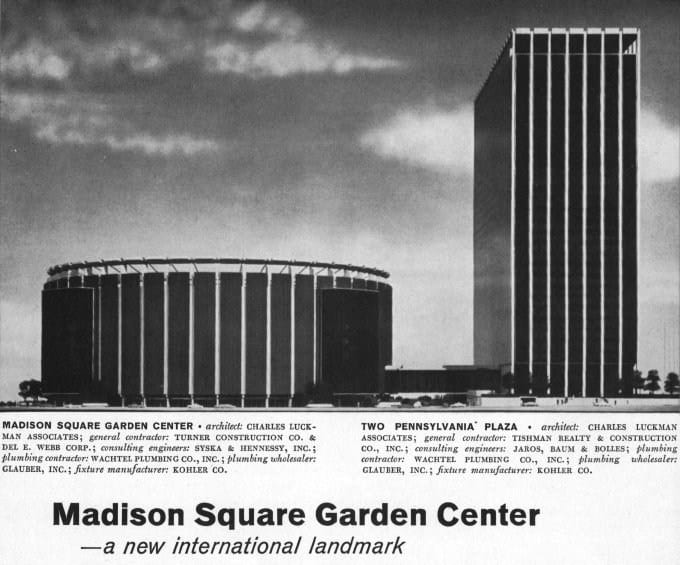
The old waiting room, [1] once the largest indoor public space in New York City, is now a parking lot. [2]

Demolition crews began hacking away at the limestone walls, stone eagles, and thirty-foot tall Doric columns of old New York Penn Station in October 1963. In a construction industry where architects typically quote projects as lasting eighteen months, the demolition and rebuilding of old Penn Station lasted five years. At its 1910 opening, old Penn Station was the largest and most expensive infrastructure project ever built in New York City. The station’s associated service tunnels stretched 5.5 miles under the Hudson and East River. At 350 feet long and 150 feet high, old Penn Station’s waiting room was the city’s largest internal space. Construction cost $100 million, or $2.7 billion in 2020 adjusted for inflation. By 1963, this was the largest and most expensive structure ever demolished in New York City.[3]
In a 1963 conversation with The New York Times, the developer justified demolition as “putting passengers first” and then clarified: “The outside is the only thing of artistic value as far as I’m concerned. The handling of 200,000 passengers is much more important to me. […] In some areas the land is just too valuable to save anything that doesn’t fully utilize it.”[4] The developer’s aspirations for Penn Station’s replacement, however misguided, were no less monumental in their imagination: to construct a profitable office skyscraper and Manhattan’s largest arena for sporting events and conventions. Office workers and event spectators could move directly from trains to their seats without stepping outside, or engaging with the public space of the city streets.

.

1968 advertisement for the new station [5]

.

“The fact is that the redevelopment of the Pennsylvania Station into a $90 million building complex will transform the area from a static uneconomic burden on the railroad into a viable commercial and recreational center of benefit to the entire West Thirty-fourth Street neighborhood and the public at large.” – Allen J. Greenough, Pennsylvania Railroad President.[6]

.

Architects have long positioned the demolition of monumental old Penn Station as a key moment in the discourse on historical preservation. This was, to quote leading New York City historian Kenneth Jackson, the moment when: “Human beings, myself included, have an unfortunate tendency to appreciate people and things only after they are gone. Pennsylvania Station is the catalyst for the historic preservation movement.”[7] The public realized that even a monument as expensive and permanent as Penn Station could vanish with no mechanism for the public to object. Activists pressured the city government to pass New York’s first ever landmarks preservation law in 1965.[8] Some historians, like Anthony Wood, have posited that the movement toward landmarks preservation began years before Penn Station’s demolition, and that this demolition was not critical in motivating landmarks preservation.[9] Nonetheless, in the following decades, the city protected over 120,000 historic buildings (comprising about 14% of New York City’s built environment).[10]
Less cited and discussed is how Penn Station’s loss parallels a larger late-twentieth-century trend to erode and privatize the commons. The demolition and rebuilding of old Penn Station is a lens to examine the competing tensions of economics vs. aesthetics and private vs. public interests. The demolition and reconstruction of old Penn Station mirrors the larger abandonment of government and corporate responsibility for maintaining and upholding public space.

Read More

.

Although Midtown’s largest building in this c.1911 photo, skyscrapers soon surrounded Penn Station.[11]

.

New York: subway city of immigrants

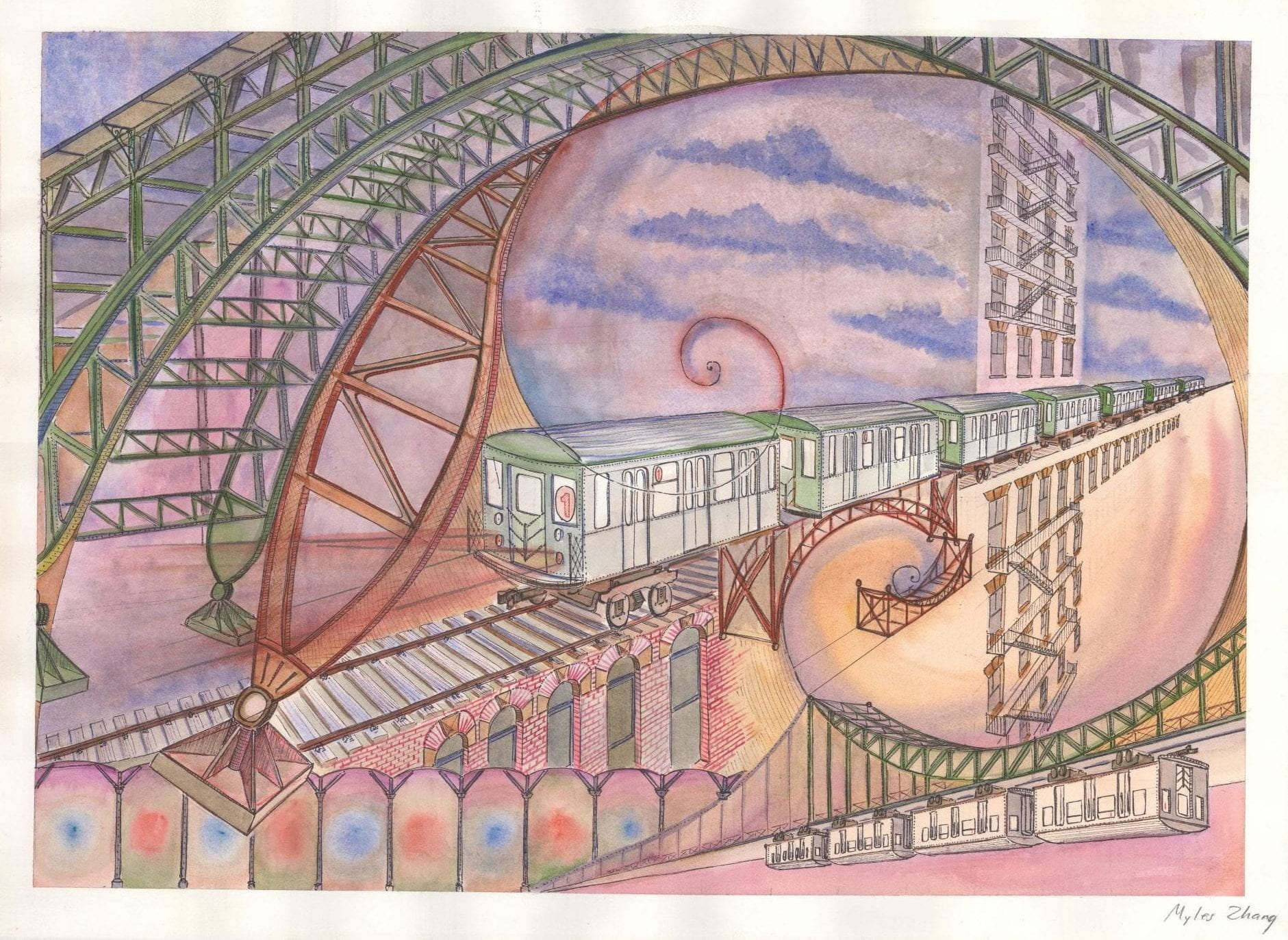
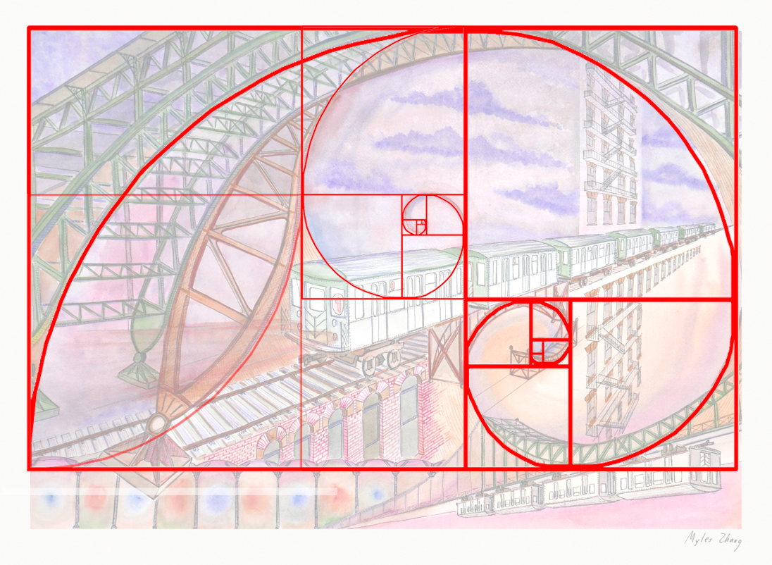
Golden Rectangles SuperimposedAs northbound Broadway dips down to the valley of 125th Street, the subway soars over the street. The subway viaduct is a jumble of steel slicing through the orthogonal city grid. The 125th Street viaduct is a massive arch, 250 feet from end to end, two hundred tons of mass channeled into four concrete pylons, resting on the solid bedrock of Manhattan schist. The subway is the intersection, where the underground and aboveground worlds of New York City converge.
New York City is now home to a peculiar race of people. Every day, New Yorkers step to the tune of the stoplight. Every day, they ride in sardine can subways. Like smoked ham on the butcher’s hook, they hang from subway straps. At their respective stops, they scramble on to work, home, and family. All New York is a stage, and all the men and women merely players. They have their entrances as subway doors slide open, and they time their exits to the familiar recording of “Stand Clear of the Closing Doors Please.” 1
The subway’s alphabet lines snake their way beneath the city and above the boulevards. Take the to Brighton Beach, the to Jamaica, or the to Forest Hills. From the towers of Midtown, to the factories of Flatbush, to the shouts of Shea Stadium, the subway is a panoply of color, motion, and people. For the price of $2.75, the world is within reach. Chinatown, Poland, Russia, Greece, India, and Italy are all neighborhoods joined by the subway’s umbilical cord. New York is a world unto herself, knit together by bands of black asphalt and steel arteries subway track.
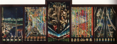
Voice of the City - Joseph Stella, 1922

Voice of the City by Joseph Stella, 1922.

Once wooded island of the Lenape Indians, Mannahatta,2 is now a city of immigrants and refugees: the Irish fleeing famine in 1845, the Germans fleeing Revolution in 1848, the Italians in 1871, and now waves of Czech and Chinese, Dominicans and Mexicans. As the metropolis pulsates in motion, the spirit of the city evolves with each wave of newcomers, who ride her subways, inhabit her humid tenements, and dream of home, family, and future.
In 1856, Walt Whitman published Crossing Brooklyn Ferry. He writes of immigrants and bourgeois businessmen alike, all part of “the simple, compact, well-join’d scheme, myself disintegrated, every one disintegrated yet part of the scheme.” Immigrants are the scheme of the city, the cogs of capitalism, and the human machinery of the metropolis. To each immigrant belongs her place, to each worker his seat, and to each vagabond a place in the breadline. Together they form the metropolis. Whitman also writes:
Others will enter the gates of the ferry and cross from shore to shore,
Others will watch the run of the flood-tide,
Others will see the shipping of Manhattan north and west, and the heights of Brooklyn to the south and east,
Others will see the islands large and small;
Fifty years hence, others will see them as they cross, the sun half an hour high,
A hundred years hence, or ever so many hundred years hence, others will see them,
Will enjoy the sunset, the pouring-in of the flood-tide, the falling-back to the sea of the ebb-tide. 3
Rome is nicknamed the “Eternal City” for its ancient architecture and generations of development. New York, too, is an “Eternal City” of sorts. Its skyscrapers may rise and fall with changing tastes and a growing economy. Yet, in the face of all change to the built environment, immigrants remain the eternal constant that marks time and life in this city: a city with over three million foreign born from all corners of the world; a city whose functioning depends on the legions of immigrant window washers, janitors, and taxi drivers without whom this urban machine would screech to a halt. In 1856, Whitman wrote of a fluid and dynamic city of people in many ways like the New York of today.

.

.

New York, you, too, are home to the injustices and inequalities urban life nurtures. Hart Island, New York’s pauper’s cemetery since 1869, is the final resting place of over a million mostly unknown corpses over 150 years, the tired, the poor, and the huddled masses of immigrant New York. Over a quarter million infants are buried here, each one in an unmarked coffin made of pine, the size of a shoe box. Mass graves are three coffins deep and are buried twenty-five in a row. Nearby Riker’s Island, America’s largest jail, imprisons 10,000 a night awaiting trial in the city’s many courthouses. The South Bronx, with a per capita income $12,500, is a mere mile away from the Upper East Side, with a per capita income over $85,000. The glassy condos of Manhattan are priced at a million plus per piece, but these homes are only made possible by the immigrant workers and janitors paid $10 an hour to sweep the hallways of dust and wipe the windows of grit. Every night, these laborers, too, return to their homes in the gritty outer boroughs. They, too, ride the subway that burrows underground, as generations have before them.
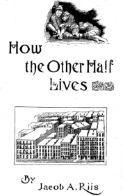
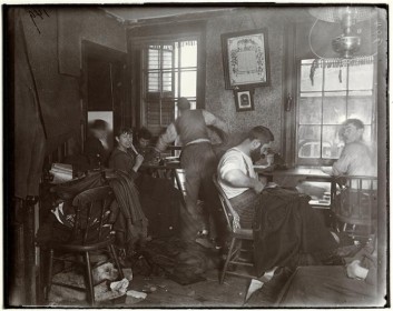
In the 1880s, social reformer Jacob Riis was working on How the Other Half Lives. Through photography, he captured the squalor, darkness, and misery of New York’s impoverished immigrant community. He showed children at work in sweatshops, vagabonds at work collecting the refuse of those more fortunate. He exposed the darkness of another world a few steps from Wall Street and a few miles from the opulent mansions and department stores of Fifth Avenue and Ladies’ Mile. 4 That very same year, on March 26th 1883, the Vanderbilt Family of railroad fortune hosted the largest and most expensive costume ball in New York history, costing six million adjusted for inflation. While the idle rich came dressed as the “Count of Monte Cristo” and “Otho the Barbarian,” the poor slept in squalor a carriage ride away in the Lower East Side. As the New York Sun reported three days later, “[This] festivity represents nothing but the accumulation of immense masses of money by the few out of the labor of the many.” 5

.

.

Though a century has passed since Riis, New York still is a city of social contrasts and economic disparities. Ironically, Jacob Riis’ Lower East Side is now a fashionable community for the upper middle class. All the same, the eternal New York City of immigrants endures in the outer boroughs of Flushing, Queens, Jackson Heights, South Bronx, and Bedfort Stuyvesant. In many regards, their social condition is not too different from Riis’ era. His images of New York testify both to how much and to how little New York has changed. America’s Eternal City still is a place of great injustices, but it is also the place where many of these injustices were first confronted and solved by the city’s activists and artists.
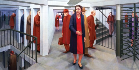
George Tooker depicts the alienation of urban life in his 1950 painting "Subway."

Subway by George Tooker, 1950.

As E.B. White wrote in 1949: “The city is like poetry: it compresses all life, all races and breeds, into a small island and adds music and the accompaniment of internal engines. The island of Manhattan is without any doubt the greatest human concentrate on earth, the poem whose magic is comprehensible to millions of permanent residents but whose full meaning will always remain illusive.” 6 Over 400 years since New York’s founding in 1609 by the Dutch, these words remain true as each generation of Men and Women creates the City in their own image. 7
New York, you have not the tree-lined boulevards of Paris, the tradition and pomp of London, or the antiquity of Rome. However, in your diversity of people, cuisine, and culture, you are something far greater. You are home to a city of strangers, a city of neighborhoods, a city of sound, a city of subways, taxis, and buses flowing from the canyons of Midtown to the quiet bedrooms of Westchester and Park Slope, like rivulets of water. Flow on city, flow with the tide, and glide through the eras. Flow on Isle of Mannahatta for “a hundred years hence,” like a ship anchored on bedrock between two proud rivers.

https://mcnyblog.files.wordpress.com/2013/08/sun-mar-29-1883-critical.pdf

Endnotes

  1. Adapted from “All the World’s a Stage” by William Shakespeare
  2. Before Manhattan was settled by Dutch explorers in 1609, it was known by the local Lenape Indians as Mannahatta.
  3. Crossing Brooklyn Ferry” from Leaves of Grass by Walt Whitman, 1856.
  4. How the Other Half Lives by Jacob Riis, 1890.
  5. The New York Sun, March 29, 1883.
  6. Quoted from Here is New York by E.B. White in 1949.
  7. “So God created mankind in his own image.” Genesis 1:27.

Manufacturing the Picturesque at Central Park

Written with Zeynep Çelik Alexander, historian at Columbia University
Inspired by Elizabeth Blackmar’s inspiring lectures on urban development and Central Park

.

Download this essay as a PDF file

.

Figure 1. Map of completed Central Park in 1873

.

Central Park is not only the major recreational facility of Manhattan but also the record of its progress: a taxidermic preservation of nature that exhibits forever the drama of culture outdistancing nature. Like the [Manhattan] Grid, it is a colossal leap of faith; the contrast it describes – between the built and the unbuilt – hardly exists at the time of its creation.
– Rem Koolhaas, Delirious New York1

.

Koolhaas presents one of the challenges core to Central Park’s construction: the tension between natural and manmade, urban and rural. What sets this park apart from most other parks is its yearning to seemingly become something that it clearly is not: natural. Many other pocket parks in this city incorporate existing topography and trees into their design – yet they are smaller. And from the confines of their interior, the sights and sounds of the city are hard to escape. Central Park succeeds in permitting its visitor to make-believe, at least momentarily, that they have left the city and are immersed in the countryside. The original park contained, for instance, a sheep pasture and barn, a nature preserve called “The Ramble,” and a dairy for urban mothers to buy fresh milk.
The scale of Central Park and the engineering that went into its creation is not unprecedented – architects and engineers have completed far larger infrastructure projects. The New York City watershed, for instance, catches all the rainfall within a 2,000 square mile area, stores this water in 19 reservoirs, and then transports this water up to 150 miles in underground pipes that serve nine million people.2 Central Park, by comparison, was built by some of the same engineers but is a mere three-square-miles of “improved” wilderness. However, what is surprising is the degree to which Central Park’s landscape features seem natural, as if land speculators and developers had chanced upon the park and left it as untouched as they had found it, except framed on four sides by the city grid (figure 5). So successful is this intervention that there is often the popular misconception that it is natural. This Huffington Post article, for instance: “I know that it may come as a shock to some, but New York’s Central Park is not an act of God. It might seem that way, especially in the woodlands, which appear so authentically, well, natural.”3

.

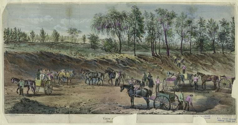
Figure 2. Earthworks projects in 1858, most likely in the vicinity of 72nd Street

.

In the 1857 text entitled “The Plan for the Park,” the project’s landscape architect, Frederick Law Olmsted (b.1822-d.1903), writes that it “seems desirable to interfere with its easy, undulating outlines, and picturesque, rocky scenery as little as possible, and, on the other hand, to endeavor rapidly and by every legitimate means, to increase and judiciously develop these particularly individual and characteristic sources of landscape effects.”4 Olmsted’s claim is a good place to start because it expresses a paradox central to the design. Olmsted’s project “interferes” with the landscape “as little as possible” simultaneously with large-scale efforts to move soil, blast rock, and plant trees that employed – at the height of work – some 4,000 men.5 Around five million cubic feet of rock and soil were blasted and removed from the park. Rem Koolhaas interprets this quote from Olmsted as follows: “If Central Park can be read as an operation of preservation, it is, even more, a series of manipulations and transformations performed on the nature ‘saved’ by its designers.”6
How can we reconcile these two seemingly opposed tendencies in Central Park – natural vs. manmade – when almost all manmade features are disguised as natural? I propose that we can better understand the park by dispensing with the pretense that it is in any way natural.
Central Park presents an unusually refined interpretation of nature. Of the approximately 20,000 trees of 175 species, solidly 60% are non-native to New York.7 Of the seven lakes contained within the park, none are natural to the terrain and are mostly the result of damning existing streams. Of the paths, trails, and roads winding through the park – with curves to match the contours of hills and valleys – none are original, nor do they correspond to pre-development dirt roads and Lenape Indian trails.8

.

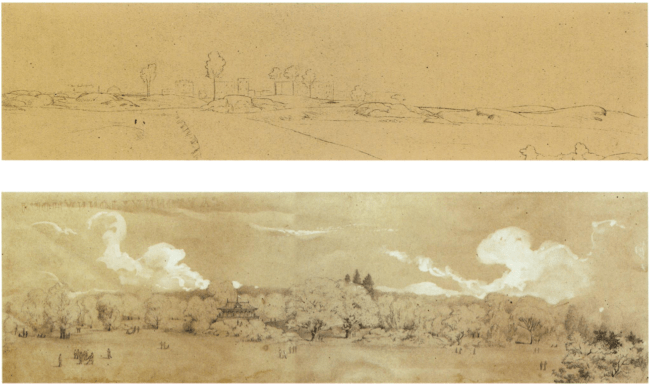
Figure 3. Frederick Law Olmsted’s 1857 drawing of the park before and after the planned “improvements.”
The style and content of this image evokes the work of English landscape architects and Humphry Repton.

.

Before work began in 1857, the pre-development topography was insufficient for use as a public park. The Manhattan grid – comprising some 2,000 plus city blocks each measuring exactly 200 feet wide – implies a flat terrain and originally made no accommodations for interfering rivers, hills, or marshes. Looking at a street map of the island, one might be surprised to learn that the terrain rises and falls the length of the island from zero feet at sea level to ~250 feet at its highest peak (figures 4 and 16).9 The name “Manhattan” is a Lenape Indian word that means “Island of Many Hills.”10 Yet, despite the variety of sites planners could have chosen from, the park’s rectangular boundaries were not determined by the availability of topographic features appropriate for a park.

.
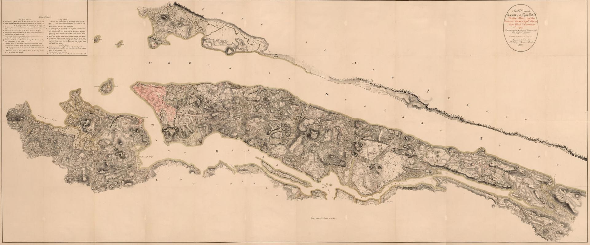
Figure 4. British Headquarters Map of Manhattan Island from c.1789. Only the shaded pink section at top of island is developed at city-level density. The rest consists of rolling hills, forest, and farmland that inspired Henry Hudson, the first European who “discovered” the island in 1609, to remark that: “The land is the finest for cultivation that I ever in my life set foot upon.”11

.

Instead of topography, three main factors determined the location: First, planners needed to choose a site close to the expanding city yet far enough away that the land could be acquired cheaply and without displacing large numbers of residents. Second, the city’s population had grown 160% in the twenty years from 1840 to 1860,12 and the city’s existing Croton reservoir (then located in the exact center of the proposed park) was insufficient. The city needed an expanded reservoir; the most convenient location on Manhattan Island for this reservoir was next to the existing one. The otherwise purely practical infrastructure of water supply could thus become a landscape feature.13 Third, the city planned to offset the approximately five-million-dollar price tag of land acquisition and construction through corresponding increases in the taxable property values of land adjacent the park. The architects also went so far as to suggest “a toll of three cents on visitors coming on foot, and six cents for all others” collected on visitors to fund park maintenance and offset construction costs. (This was never implemented.)14 Olmsted also writes:
Land immediately about the Park, the frontage on it being seven miles in length, instead of taking the course anticipated by those opposed to the policy of the Commission, has advanced in value at the rate of two hundred per cent per annum. […] It is universally admitted, however, that the cost, including that of the original off-hand common sense blunders, has been long since much more than compensated by the additional capital drawn to the city through the influence of the Park.15
The park’s location might be strengthened by the simple fact that a linear or smaller park along the waterfront would have fewer miles of frontage of taxable properties adjacent to the park. For instance, locating just one side Central Park along the Hudson and East River (instead of the island’s center) would result in 2.5 miles fewer of abutting properties. Within the following decades, the properties in the Upper East and Upper West Side that overlook the park became (and remain) among the most expensive in the city. This method of development – sacrificing a fraction of the land for park use so as to increase the monetary value of the adjoining lands – was common in New York City (e.g., Gramercy Park) and particularly in London’s fashionable West End and Hyde Park neighborhoods.16 What makes Central Park different, though, is the unprecedented scale of this investment to boost civic pride and to increase property taxes.

.
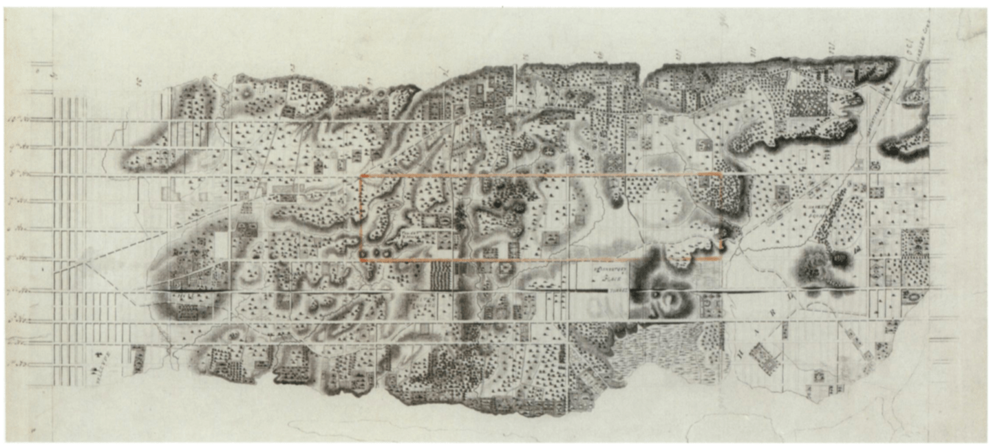
Figure 5. A c.1836 engraved map of mid-Manhattan with the outline of the future park drawn in orange ink c.1858. The incongruity between the park’s outline and the topography is also illustrated by the fact that the park’s northern boundary (originally at 106th street) would require blasting through a one hundred foot high solid-rock mountain to make way for the perimeter street.

.

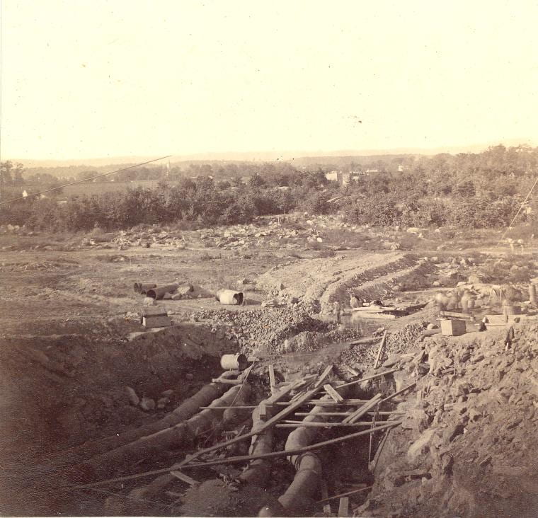
Given these priorities – real estate and infrastructure interests over aesthetics – the choice of location was not ideal (figure 5). The rough terrain was mostly barren of trees and was a mosquito-laden wetland. (More readily converted and forested terrain was originally proposed along the East River in the vicinity of Roosevelt University.) Before beginning the architect’s work of planting trees and building scenic garden features, the first major task was to prepare the land and make it suitable for public use. To that effect, Olmsted contracted the engineer (and later military coronel) George E. Waring to drain the swamp. Waring directed 400 men to construct some 105,000 linear feet (32 kilometers) of drainpipes over two years (figure 8).17 His military-style approach toward clearing the park followed him into later life when he became New York City’s sanitation commissioner. As commissioner, he required all his street cleaners to wear white pith helmets (identical to those worn by European colonists in Africa) and then declared the war on filth. Given his interest in sanitation and dislike of dirt, his answer to the park commissioners’ question is revealing:
Commission’s Question: “To what degree shall the park be drained?”
Waring’s Answer: “Totally.”
Q: “By what form of drains?”
A: “Earthenware, of varying calibers.”
Q: “At what depth?”
A: “Three feet in open glades, four feet in forested areas.”
Q: “For best economy, by contract or days’ work?”
A: By days’ work because of the endlessly varied conditions requiring uncommon on-site super vision.”18

.

Figure 6. Buried Pipes in Connection with the New Reservoir, c.1862.

.
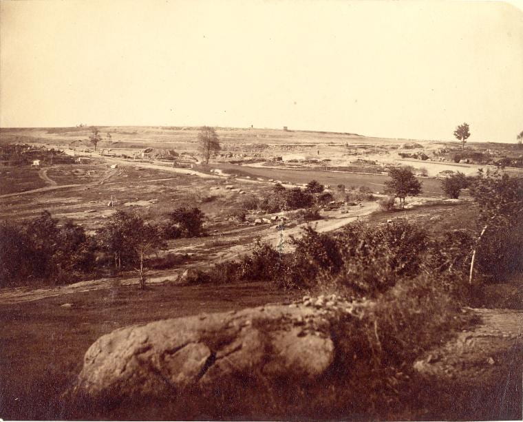
Figure 7. General View of North Reservoir from 102nd Street, 23 October 1862.
All the land visible here is now buried beneath the reservoir.

.

Another requirement asked of the planners was to incorporate a new reservoir into the park (figures 6-7 show terrain now flooded beneath reservoir). The existing stone reservoir and Croton Aqueduct, completed 1842, were no longer sufficient19 despite Walt Whitman’s claim that: “Ages after ages these Croton works will last, for they are most substantial than the old Roman aqueducts.”20 To augment the Croton’s capacity, the new reservoirs combined covered approximately 20% of the park’s surface area over terrain that otherwise would have become parkland. Before Olmsted had even submitted his plan in 1857, the engineer Egbert L. Viele, who had been surveying the parkland since 1853,21 had decided on placing this reservoir on a natural depression in the land, to be augmented by an earthen embankment around the perimeter. Olmsted’s final proposal follows the contours of Viele’s proposed reservoir exactly – illustrating the degree to which engineering needs dictated the landscape architect’s choices.

.
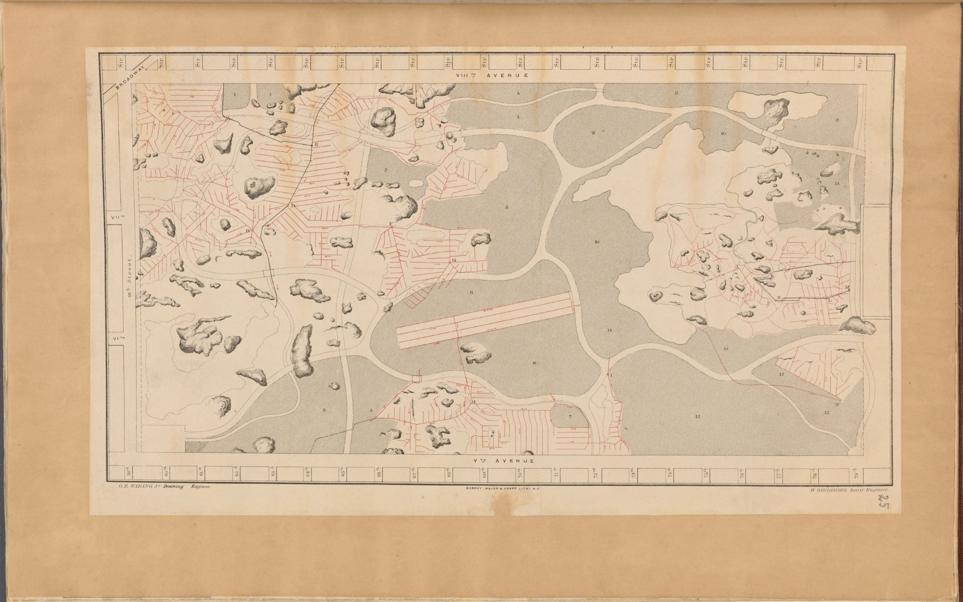
Figure 8. Map of drainage system on lower part of the Central Park as far as completed up to 31 December 1858. On the left is 59th Street, 5th Avenue is at bottom, and 8th Avenue (i.e. Central Park West) is at top. This map only illustrates the paths of future carriage roads within the park – that is, the thick white lines that wind through the landscape. Red lines indicate the buried clay pipes that drain water from the marshy soil – and many continue to do so today. Shaded gray areas correspond to areas to be raised with dirt fill. The shaded blotches are for preserved boulders protruding above ground. The slightly off-kilter rectangle in center is for the area drained to create the Central Park Mall – the only geometrically symmetrical part of the park.

.

Although the park was extensively surveyed and re-landscaped there was, nonetheless, an attempt to appear rustic and unkempt. The architect, Calvert Vaux, blanketed the park in little pavilions and bridges made from unpolished and rustic wood with bark still on the beams – a nineteenth-century re-reading of the primitive hut.22 The passage from the southern to the northern reaches of the park was also a parable in the march of civilization and progress. By this time, the city was advancing northward up the island from its historic center in Lower Manhattan (figure 9). Within forty years, the island would be completely built-up. With this recognition of urban sprawl, Olmsted named the park’s 16 original entrances to reflect the city’s movement and types of people living in New York. In order from south to north, the names are as follows: Artisan’s Gate, Merchant’s Gate, Scholar’s Gate, Woman’s Gate, Inventor’s Gate, Miner’s Gate, Mariner’s Gate, Engineer’s Gate, Gate of All Saints, Woodman’s Gate, Boy’s Gate, Girl’s Gate, Stranger’s Gate, Warrior’s Gate, Farmer’s Gate and Pioneer’s Gate. This list almost reads as a list of social classes in increasing order of proximity to raw nature.23 The design features also evolve over distance. The southern reaches (also the busiest section due to the proximity to the city center) was built first and included more pruned botanic features, rectangular parterres of trees, and the proposed flower garden. Olmsted thought it appropriate to leave the northern reaches of the park as wooded as possible with a c.1812 fortress left standing atop a mountain as a picturesque ruin in the style of English garden follies. The northern reaches (also surrounded mostly by farmland at this time) were intentionally more heavily forested, had fewer of the park’s signature bridges, retained the park’s largest rock escarpment, and for the first few decades of its life contained no statues, monuments, or plaques commemorating important people. By contrast, about two dozen monuments to Western Civilization’s great cultural and political leaders (all male) were concentrated in the south: William Shakespeare (installed 1872), Thomas Moore (1879), Alexander Hamilton (1880), Beethoven (1884), Columbus (1894), etc.24 Paradoxically, while the south may appear more refined and cultivated than the north, the pre- development terrains in both sections were equally crafted and manipulated. There is, here, the illusion of moving north toward nature, instead of the reality.

.
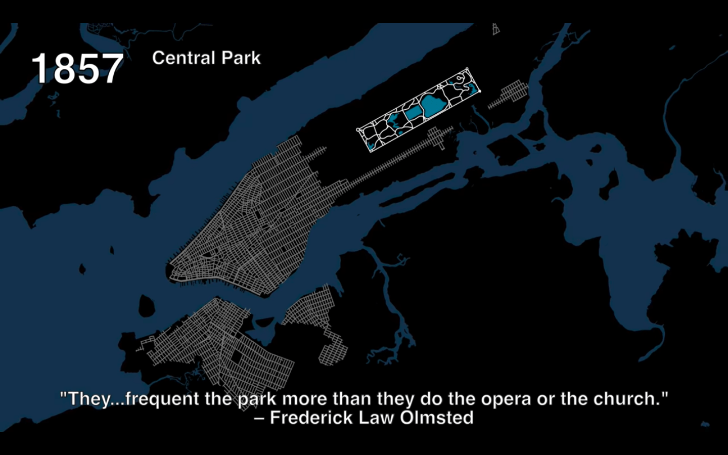
Figure 9. The extent of northward marching urban development by 1857, with the park beyond the developed city. Notice how large the park is relative to the city’s surface area, and how the city becomes rural travelling north. View this animation online.

.

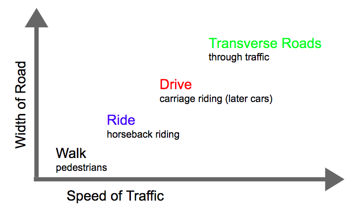
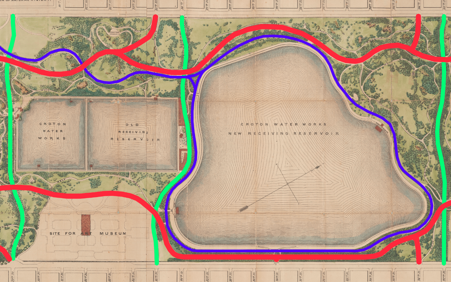
At this stage, we might arrive at a better understanding by shifting the descriptive language. Perhaps we should describe the park not in terms of nature or landscape – given that considerations of the natural were not foremost in the design. We might do better to describe the park in terms of infrastructure, engineering, movement, and social class. Indeed, one of the strengths of Olmsted’s proposal – and one of the reasons he won out of the 33 designs submitted – was his decision to separate the park by four different social classes and speeds of movement (figures 10 and 11), each of which corresponded to a width of road and minimum permitted vehicle turning radius (color-coded in figure 12).25 This detailed plan for road separation and drainage were finished before the architects had even begun working on planting diagrams or selecting which species of trees would make for the most varied landscape composition. There were four classes of segregated roads. First, because of the park’s length, size, and location, there would be many vehicles passing through the park, not for leisure, but simply to pass from one side of the park to the other as fast as possible. For these vehicles, the engineers planned four buried transverse roads with entirely separate right-of-way. These straight and wide roads at no point intersected other types of traffic and were entirely below grade level. Second, there were carriage roads for slightly slower carriage traffic within the park. While the relatively straight transverse roads were for practical through-traffic, these carriage roads were for leisure. Third, the next highest speed consisted of a narrower and more curving path than the carriage roads, gravel paths for horseback riders. Horseback riding was a popular leisure and sporting activity – these roads are now largely used for joggers who move faster than pedestrians but slower than vehicles. Fourth, the most ubiquitous road type of all consisted of unpaved footpaths for pedestrians on foot only. With the help of bridges and tunnels (figure 11), at no point did these four systems of conveyance intersect, leading Olmsted to claim: “By this means it was made possible, even for the most timid and nervous, to go on foot to any district of the Park designed to be visited, without crossing a line of wheels on the same level, and consequently, without occasion for anxiety and hesitation.”26

.

Figure 10. Author’s diagram of road types

.
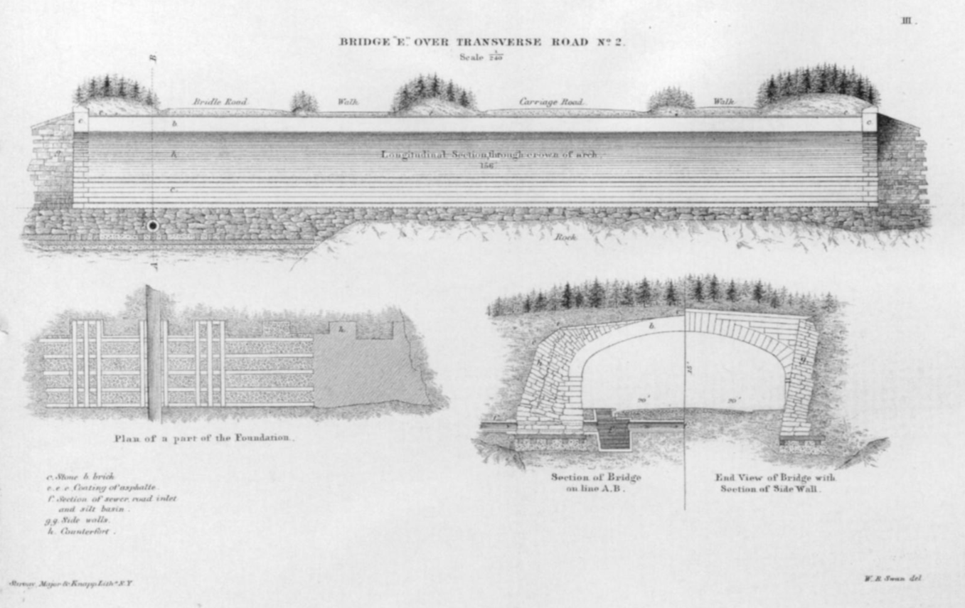
Figure 11. 1862 cross-section of transverse road. Notice how the trees above the road are drawn small, as if to exaggerate the tunnel’s monumentality.

.

WALK          RIDE          DRIVE          TRANSVERSE

Figure 12.

.

Incidentally, these separate and unequal paths also corresponded to different social classes. The wealthiest individuals – those who could afford a carriage, horse, and driver – would implicitly have exclusive use of the carriage roads, while horseback riders had their separate right of way, and service vehicles were segregated below grade. The rest of the public and working classes were restricted to the footpaths, where security guards patrolled the park and prohibited them from loitering, picking flowers, picnicking, or forming large groups. Elizabeth Blackmar and Roy Rozenzweig write: “In the decade after the opening, more than half of those visiting the park arrived in carriages (which less than 5 percent of the city’s population could afford to own, and each day there were elaborate carriage parades in the late afternoon.”27 Yet, disproportionate design considerations and park surface area seems to be given to this minority of users on carriages. We should return here to the fact that city leaders intended this park to boost property values and taxes on the wealthy residents who lived adjacent to the park. It is only natural, then, that the park design should reflect their interests and preferences.

.

.


Figure 15. Map of middle section of the park between the 79th Street and 97th Street transverse roads, the empty area at lower left hand corner is the future site of the Metropolitan Museum of Art. The blue road corresponds to the horseback trail, now jogging path. After starting at the 59th Street entrance and passing through manmade forests, valleys, and tunnels, horseback riders’ visual experience culminated as they circled this manmade reservoir.

.

These maps of the park – color coded by road type – can help us begin to unravel the degree to which the current landscape is manmade. At first glance, the smooth passage of roads and their organic contours may seem effortless, as if they were laid out along existing roads with regards to existing topography. By separating the different grades of traffic by color (figure 14) and upon closer examination, there is a complex and extensive hidden infrastructure beneath these natural appearances (figure 13).

.

Figure 16. 1811 Commissioners’ Plan

.

These maps also reveal a park that is not separate from or opposite to the city, but instead a continuation of the city. A glance at a map of Manhattan reveals two seemingly different philosophies of urbanism, as imprinted through the laying of road networks. Most of the island is covered in the orthogonal 1811 grid (figure 16). This grid gives no consideration to topography, nature, or aesthetics. Then, there is the three square mile area of Central Park with winding and seemingly organic roads. The absence of symmetry and straight lines might lead one to conclude that the park reflects an attempt to harmonize with nature. Existing popular literature commonly situates this park as a reaction to the grid’s perceived faults and excesses. Upon closer examination, this park’s near obsessive attention to detail, its concern with segregated movement, and its reliance on complex (but hidden) infrastructure reveal the park to be a continuation of the 1811 grid’s interest in real estate, property values, and engineering, more than it is a prosaic and romantic reaction to excessive urban growth. This infrastructure is also wrapped up in a coded message about the progress of civilization. The passage from cultivated south to rugged north can read as a condensed representation of the passage from the center of civilization to its undeveloped edges. One should also keep in mind that simultaneous to the construction of Central Park, engineers and developers were at work on the other side of the country clearing the American West for development. Within the following decades, the extent of farmed land would creep westwards on former Indian soil, generally following the paths of railroads toward California. Does the design of Central Park mirror 1860s American society’s belief in the civilizing power of science and technology to tame the wilderness? Alternatively, is Central Park’s design just a matter-of-fact effort to boost the city’s tax revenues, with no moral agenda intentionally encoded in the park design? Such questions might be impossible to answer, given the lack of conclusive evidence.
Now is the time to return to the question we started with: How can we reconcile these two seemingly opposed tendencies – natural vs. manmade? I posit that by describing Central Park in the language of infrastructure and real estate – instead of nature and aesthetics – we can arrive at a more accurate assessment of the park’s origins, objectives, and construction process. Seemingly, the only way to adapt this ill-suited site into a park that fulfilled the nineteenth-century definition of the picturesque was through public works that, upon their completion, effaced almost all traces of the people, trees, and landscape that existed before. The engineering here succeeds insofar as it is invisible and functions as if no manmade intervention had ever occurred. While at work, Olmsted made this prediction on the future of Manhattan Island:
The time will come when New York will be built up, when all the grading and filling will be done, and when the picturesquely-varied rock formations of the Island will have been converted into formations for rows of monotonous straight streets, and piles of erect buildings. There will be no suggestion left of its present varied surface, with the single exception of the few acres contained in the Park.28
The park is an architectural contradiction. On the one hand, its rock formations, hills, and valleys look to a pre-developed and rugged Manhattan in the public imagination, a landscape more fictive than real. On the other hand, the park’s very presence is a testament to the power of real estate interests, engineers, and the water supply board in shaping the city. This tension underlies the landscape features now almost universally praised for their vision, beauty, and harmony.

.

.

List of figures

  1. Lionel Pincus and Princess Firyal Map Division, The New York Public Library, “Map of the Central Park” New York Public Library Digital Collections, http://digitalcollections.nypl.org/items/4e6a6080- 3569-0134-549e-00505686a51c (retrieved 4 May 2019).
  2. Art and Picture Collection, The New York Public Library, “View in Central Park, Promenade, June 1858,” New York Public Library Digital Collections, http://digitalcollections.nypl.org/items/510d47e1- 0fb6-a3d9-e040-e00a18064a99 (retrieved 4 May 2019).
  3. Frederick Law Olmsted and Calvert Vaux (designers); Calvert Vaux (artist), Greensward Plan presentation board with “Present Outlines” (above) and “Effect Proposed” (below): No. 1. From Point A (view at Fifth Avenue entrance), 1858, graphite, wash and white lead on paper, New York Municipal Archives.
  4. Lionel Pincus and Princess Firyal Map Division, The New York Public Library. “Map of New York City and of Manhattan Island with the American defences in 1776,” New York Public Library Digital Collections, http://digitalcollections.nypl.org/items/ee2f1060-d488-0135-3577-67321a8090bc (retrieved 4 May 2019).
  5. David H. Burr (cartographer), Topographical Map of the City and County of New-York and the Adjacent Country (proof impression of center sheet), published by J.H. Colton and Co., New York, 1836, engraving, ca. 1836, the Metropolitan Museum of Art.
  6. Rare Book Division, The New York Public Library, “Pipes in Connection with the New Reservoir,” New York Public Library Digital Collections, http://digitalcollections.nypl.org/items/510d47e3-6289- a3d9-e040-e00a18064a99 (retrieved 4 May 2019).
  7. Rare Book Division, The New York Public Library, “General View of N. Reservoir from 102nd St. October 23, 1862,” New York Public Library Digital Collections, http://digitalcollections.nypl.org/items/510d47e3-6288-a3d9-e040-e00a18064a99 (retrieved 4 May 2019).
  8. Lionel Pincus and Princess Firyal Map Division, The New York Public Library, “Map of Drainage System on Lower Part of the Central Park as far as completed up to December 31st, 1858,” New York Public Library Digital Collections, http://digitalcollections.nypl.org/items/7fe3e680-0c6a-0132-bc3c- 58d385a7bbd0 (retrieved 4 May 2019).
  9. Author’s illustration from Here Grows New York animation, https://youtu.be/f6U7YFPrz6Y?t=226 (retrieved 5 May 2019).
  10. Author’s diagram of road types
  11. Calvert Vaux (architect), W.B. Swan (delineator), and Sarony, Major, and Knapp (lithographers), Bridge “E” over Transverse Road No. 2, 1861, lithograph, from Fifth Annual Report of the Board of Commissioners of the Central Park, January 1862, the Metropolitan Museum of Art.
  12. “Map of the Central Park” New York Public Library Digital Collections, 1873, modified by author with blue, red, and green color-coding.
  13. “Map of Drainage System on Lower Part of the Central Park as far as completed up to December 31st, 1858.”
  14. 1873 map of Central Park, color-coded by author to indicate types and widths of roads
  15. Ibid.
  16. Manuscripts and Archives Division, The New York Public Library, “Plan of Manhattan Island,” New York Public Library Digital Collections, http://digitalcollections.nypl.org/items/26e27e80-be8a-0131- bf1a-58d385a7bbd0 (retrieved 4 May 2019).
  17. Irma and Paul Milstein Division of United States History, Local History and Genealogy, The New York Public Library, “Central Park Tunnel,” New York Public Library Digital Collections, http://digitalcollections.nypl.org/items/a44288b4-9bdc-b31f-e040-e00a18060314 (retrieved 5 May 2019).
  18. Rare Book Division, The New York Public Library, “Men standing on Willowdell Arch,” New York Public Library Digital Collections, http://digitalcollections.nypl.org/items/94b7acd9-dc81-74f7-e040- e00a18063585 (retrieved 5 May 2019).

.

Works cited

  1. Rem Koolhaas, “Prehistory,” in Delirious New York (New York: The Monacelli Press, 1994), p.21.
  2. Kenneth Jackson, Lisa Keller, et al., “Water Supply,” in The Encyclopedia of New York City (New Haven: Yale University Press, 2010), p.1381-86.
  3. Charles A. Birnbaum, “The Big Task of Managing Nature at New York’s Central Park,” The Huffington Post, 12 September 2012, https://www.huffpost.com/entry/an-unlimited-range-of-rur_b_1870450? (retrieved 15 May 2019).
  4. Kenneth Jackson and David Dunbar (editors), “Selected Writings on Central Park, Frederick Law Olmsted (1858, 1870),” in Empire City: New York through the Centuries, (New York: Columbia University Press, 2002), p.279. This anthology of urban history assembles various primary sources from across NYC history into a single book.
  5. Ibid., “Central Park,” p.222-24.
  6. Rem Koolhaas, Delirious New York, p.23.
  7. Robert Demcker, “Central Park Plant List and Map Index of 1873,” published by the Frederick Law Olmsted Association and The Central Park Community Fund, 1979.
  8. Concluded from comparing maps of the park pre and post construction.
  9. Hilary Ballon, “Introduction,” in The Greatest Grid: The Master Plan of Manhattan 1811-2011 (New York: Columbia University Press, 2012), p.13-15.
  10. Eric Sanderson et al., The Welikia Project, https://welikia.org/about/how-it-all-began/ (retrieved 15 May 2019). – Sanderson created the most detailed visualization of Manhattan’s pre-development topography.
  11. “Early Descriptions of New Netherland,” New Netherland Institute: Exploring America’s Dutch Heritage, https://www.newnetherlandinstitute.org/history-and-heritage/additional-resources/dutch-treats/early-impressions-of- new-netherland/ (retrieved 15 May 2019).
  12. “NYC Total and Foreign-born Population 1790 – 2000,” NYC Planning Department, https://www1.nyc.gov/site/planning/data-maps/nyc-population/historical-population.page (retrieved 15 May 2019).
  13. The old rectangular shaped Croton Reservoir covered 8% of the park’s area. The new reservoir covered about 12%. Combined they covered 20%. Values calculated by author using Google MyMaps.
  14. Frederick Law Olmsted and American Social Science Association, Public Parks And the Enlargement of Towns: Read Before the American Social Science Association At the Lowell Institute, Boston, Feb. 25, 1870, (Cambridge: Printed for the American Social Science Association, at the Riverside Press, 1870), p.35. https://catalog.hathitrust.org/Record/008726621 (retrieved 4 May 2019).
  15. Ibid., p.35.
  16. Jon Campbell and Christopher Robbins, “The Origin Story Of Gramercy Park Is A Classic NYC Tale Of Real Estate Hucksterism, Cronyism, And Gate Crashing,” The Gothamist, 28 June 2018, http://gothamist.com/2018/06/28/gramercy_park_history_amazing.php (retrieved 15 May 2019).
  17. Morrison H Heckscher, “Creating Central Park,” The Metropolitan Museum of Art Bulletin, New Series, 65, no. 3 (2008): p.40, http://www.jstor.org/stable/25434142 (retrieved 15 May 2019).
  18. Ibid.
  19. A mere 94 years after opening, the old Croton reservoir was deemed inadequate, drained of water, and filled with debris from subway excavations.
  20. “Murray Hill Reservoir, November 25, 1849, Walt Whitman,” in Empire City, p.207.
  21. “Creating Central Park,” p.18.
  22. Patricia Heintzelman for the U.S. Department of the Interior, Central Park Nomination Form for NRHP, 1966, https://npgallery.nps.gov/AssetDetail/NRIS/66000538 (retrieved 15 May 2019).
  23. To my knowledge, the claim that Olmsted named the gates in 1862 to mirror the transition from civilization to nature has never been made before. However, Olmsted describes in writing how the terrain should evolve from smooth to rough during the passage north; it follows for naming conventions to reflect this shift.
  24. Wikipedia assembles lists of monuments, parks, streets, etc. organized as metadata with lat-long coordinates. Plotting these coordinates on a map and eliminating recently added monuments reveals a clear spatial concentration of artwork and sculpture in the south. https://en.wikipedia.org/wiki/List_of_sculptures_in_Central_Park (retrieved 16 May 2019). Identical list also found from NYC Parks Department: https://www.nycgovparks.org/parks/central- park/monuments (retrieved 16 May 2019).
  25. Landmarks Preservation Commission, Central Park Designation Report for the NYC Planning Department, 1974, http://s-media.nyc.gov/agencies/lpc/lp/0851.pdf (retrieved 15 May 2019).
  26. “Selected Writings on Central Park, Frederick Law Olmsted (1858, 1870),” in Empire City, p.281.
  27. “Central Park,” in The Encyclopedia of New York City, p.223.
  28. “Selected Writings on Central Park, Frederick Law Olmsted (1858, 1870),” in Empire City, p.279.